Featured Listings


About
Santa Barbara Beaches
Arroyo Burro Beach
Arroyo Burro Beach County Park is the official name of what Santa Barbara locals call Hendry’s Beach. This beach is surrounded by tall bluffs with parks and trails on top including the Douglas Family Preserve, a wooded space saved from development by locals and even Michael Douglas who named it in honor of his father Kirk. A footpath into the preserve begins at the entrance to the parking lot. Overhead at Hendry’s there are hang gliders and paragliders that take off from Elings Park nearby. Right at the beach is the Boathouse Restaurant so you can make this an all day affair or an evening visit for dinner. This is one of the cleanest beaches in the area because adults and kids venture out from the South Coast Watershed Resource Center to clean it monthly. The water however can be unsanitary if the creek is flowing so ask lifeguards if you plan to swim. The center is located at the same parking lot as Hendry’s and offers education programs for local kids (learn more at ExploreEcology.org). It’s possible to walk quite a ways in both directions from here especially at lower tides. The parking lot entrance for Hendry’s Beach is just west of the intersection of Cliff Drive and Los Positas Road. This is a popular beach so the parking lots fill up quick on nice days. Arroyo Burro Creek flows across the beach sometimes. South of this creek dogs are allowed to roam free if under voice control.
East Beach of Santa Barbara
East Beach in Santa Barbara is located along the waterfront east of State Street and the Stearns Wharf Pier area. Most of the activity at East Beach happens at the east end where the beach is widest. At this end there are many sand volleyball courts, a grass park with picnic tables, an arts pavilion (Cabrillo Pavilion Arts Center), and a restaurant (East Beach Grill). Across the street from East Beach is a paved bike path that goes all the way west to UCSB and east to Butterfly Beach. Also, across the street and down the path a little is the Andree Clark Bird Refuge Lagoon for bird-watching. Closer to the Wharf the beach narrows a bit and a palm tree lined grass park called Chase Palm Park provides a buffer between the sandy beach and the busy street. This central part of East Beach is less populated than the area near the pavilion. Parking for East Beach can be found along East Cabrillo Boulevard and also in lots located at Ninos Drive, Corona Del Mar Drive, and Garden Street.
Hope Ranch Beach
Hope Ranch Beach has a private beach access in the residential community of Hope Ranch. This unincorporated community is sandwiched between Santa Barbara and Goleta. Hope Ranch is one of the wealthiest areas of California, but it is not gated off so the general public can drive through it. The main road through it is Las Palmas Drive which turns into Marina Drive near the ocean. Unfortunately, but not surprisingly, the beach at Hope Ranch has a gated entrance on Las Olas Drive that is only for the residents to use. Fortunately the scenic drive through Hope Ranch eventually turns onto Cliff Drive which leads to Arroyo Burro Beach, a local favorite. If you really have to see what Hope Ranch Beach looks like, then walk the trail across nearby More Mesa Park and descend to the sand where if you turn left it’s about a half-mile to Hope Ranch Beach. This route might not be dry at high tide, but since high tide is usually at the back of the beach it means that Hope Ranch Beach is public property. It’s just not easy to get to for most of us.
Leadbetter Beach
Leadbetter Beach is a locals beach located just west of the harbor in Santa Barbara. It’s right across the street from Santa Barbara City College so expect to see students here on sunny days. It’s an excellent wide sandy beach that is perfect for sunbathing. With the right conditions, it gets breezy so windsurfing, kiteboarding, kite flying, sailing, and even beginner surfing all take place here. At the center of the beach is Shoreline Beach Cafe a great place for lunch. At the east end of the beach are more restaurants next to the Santa Barbara Maritime Museum on the harbor. Behind the beach is Leadbetter Beach Park, a grassy spot with picnic tables and barbeques. A larger grass park called Shoreline Park is at the west end of Leadbetter Beach which makes a nice walk from here. A paved path follows the waterfront east from Leadbetter creating a bike route full of things to see along the way. The parking lot for Leadbetter Beach is located at Shoreline Drive and Loma Alta Drive just west of the Santa Barbara Harbor main entrance.
Mesa Lane Beach
Mesa Lane Beach is a narrow beach below the West Mesa neighborhood of Santa Barbara. At low tides, this beach is wide enough for sunbathing and beach sports, but at high tide there is little dry sand. It requires a hike down a steep stairway to reach the beach here. It’s ironic that it takes more stair steps to get to the beach at Mesa Lane than at Thousand Steps Beach just east of here. West of Mesa Lane Beach the beach continues to be narrow below the Douglas Family Preserve and eventually opens up at Arroyo Burro Beach, aka Hendry’s. You can get to Mesa Lane Beach by turning toward the ocean onto Mesa Lane from Cliff Drive and continuing to the end at Edgewater Way. There is no parking lot at this location, but there are street parking spaces all along Mesa Lane and other streets nearby. A paved path leads to the top of the stairs.
More Mesa Beach
More Mesa Beach is a narrow beach hidden away below the bluffs of More Mesa Park in Santa Barbara. Due to its seclusion it has a reputation as a clothing-optional beach. The main access is at the end of Mockingbird Lane in the Vista La Cumbre development, but you can’t park there so find a parking spot along Vieja Drive or Puente Drive and walk down Mockingbird. After crossing the wide open mesa heading straight for the ocean (staying on east side of the park), look in some trees to find the only way down the steep bluff. It’s a steep path with steps to help keep your footing. If you turn right at the bottom of the stair it is a clothing-optional beach, but if you go left it is not (local rule). If you continue to the left for a half mile, you’ll be at Hope Ranch Beach. At high tide the beach here will be all wet and might not be passable at all.
To get here, turn off Hollister Avenue onto Puente Drive which turns into Vieja Drive near Mockingbird Lane. An alternate entrance that is farther from the beach access path can be found down Patterson Avenue where pull-out parking spaces next to trailheads can be found. The More Mesa Preservation Coalition has been fighting to preserve this land which is mostly privately owned. Much of it is designated as environmentally sensitive, but the northeast portion could be developed on soon. This could possibly block the Mockingbird Lane access and impact the entire property.
Shoreline Park Beach
Shoreline Park is a linear grassy park located in the East Mesa neighborhood of Santa Barbara, CA. Below the park is a narrow rock and sand beach that is backed by steep cliff walls. These walls are pocked with small alcoves and other unique natural features to discover. There is a stairwell to the beach near the center of the park. At low tide there are tide pools to explore, but at high tide the beach is narrow or all covered up by the surf. From the bottom of the stairs you can walk on the sand west (right) to Thousand Steps Beach at Santa Cruz Boulevard, but this one is also narrow. If you are looking for a typical wide sandy beach, Leadbetter Beach is down a ramp at the east end of the park. Shoreline Park has paved walking paths with benches looking over the edge of the cliffs. This is a great spot for whale watching and views of the Channel Islands. Because the park is up on a bluff, it also has views back toward the Santa Ynez Mountains. Shoreline Park has two parking areas at each end of the park off of Shoreline Drive. To get here, head west on Cabrillo Boulevard from the Santa Barbara Waterfront and look for the park on the left after the road turns into Shoreline Drive.
Thousand Steps Beach
Thousand Steps Beach is a rock and sand beach below homes high on the bluff in the East Mesa area of Santa Barbara. It requires a long hike down a stairway to get to the beach. The concrete stairs, originally constructed in 1923, have what seems like 1000 steps, but is actually closer to 150. The spot where you land on the beach is only a short jaunt from Shoreline Park Beach just to the east. Beaches along this shoreline are not known for sunbathing, but they are excellent places for tide pool exploration at low tide, and beach walking except at high tide when the beaches are all wet. If you walk far enough west you’ll reach another long stairway at Mesa Lane Beach. Thousand Steps Beach is located at the dead end of Santa Cruz Boulevard just off Shoreline Drive. Unfortunately, there is only room for a handful of cars at the top of the stairs. Street spaces can be found along Shoreline Drive and on Santa Cruz Boulevard across the street.
West Beach of Santa Barbara
West Beach in Santa Barbara is a wide beach located west of and adjacent to Stearns Wharf Pier at State Street. A bike path leads from here west to UCSB campus and east to Butterfly Beach for biking, skating, or just walking the waterfront. Be sure to visit the pier for shops and restaurants or the Ty Warner Sea Center, an interactive marine education facility, if you have kids to entertain. Other dining and shopping options are at the nearby harbor and up State Street. Chase Palm Park and Recreation Center is located on both sides of Cabrillo Boulevard east of the Wharf Pier. An impressive skatepark called Skater’s Point can be found at Chase Park. At the Santa Barbara Harbor parking area just steps from the beach is Los Banos Public Pool and the West Beach Wading Pool for kiddos. The West Beach area of the waterfront has a lot of offer, but the beach itself is best for volleyball, kayaking, and boating. Because it’s so close to the harbor, swimming is not advised from the beach. Look for parking along Cabrillo Blvd, in the lot just east of the pier at Garden Street, or even on the pier. East Beach can be found at the other end of Cabrillo Blvd where many volleyball courts and a beachside cafe can be found.
Montecito Beaches
Butterfly Beach
Butterfly Beach is located along Channel Drive in ritzy Montecito, CA. This is a popular beach with Santa Barbara area locals, many who walk their dogs at the water’s edge. The beach has been eroded here so the sandy part is thin sometimes especially at high tide and after winter storms. Rocks and broken concrete barriers are trying to protect the bluff and the road. Getting here is easiest if you just drive toward the ocean on Olive Mill Road which turns into Channel Drive near the Four Seasons Biltmore Resort. Park along the waterfront on Channel Drive or on Butterfly Lane if necessary. Near Butterfly Lane there is a stair to the widest part of the beach. At lower tides, it’s possible to walk all the way to East Beach in Santa Barbara. In the other direction the narrow shoreline leads to Hammonds Beach. There is a paved bike path that runs from the Santa Barbara Pier to Butterfly Beach if you are coming from the city and have a bike or wish to rent one. There are no public restrooms at Butterfly Beach so plan accordingly.
Hammonds Beach
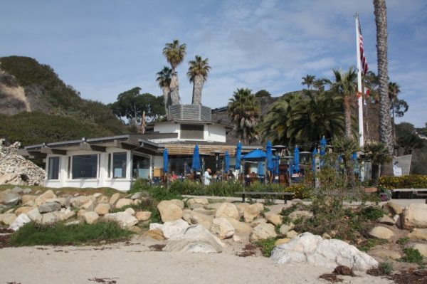
Hammonds Beach is a locals beach and a surfing spot in the Montecito area of Santa Barbara County. The beach here is a nice sandy spot hidden away amongst homes on several private drives. Behind the beach is an undeveloped open area known as Hammonds Meadow. Hammonds Beach shares a small parking lot with Miramar Beach located at the end of Eucalyptus Lane. To get here, drive toward the ocean on San Ysidro Lane which becomes Eucalyptus Lane after passing under Highway 101. At lower tides you can walk west (right) along the beach in front of the homes to get to Hammonds Beach. Most of the time it is much easier to walk the Hammonds Meadow Trail from the parking lot to where it ends on the beach. Montecito Creek sometimes flows out to the ocean at this location.
Miramar Beach
Miramar Beach is a public beach in front of a gated community called Miramar Beach in Montecito, CA. This is a nice south-facing cove with a sandy beach. The Miramar Hotel Resort used to be on the beach in the center of the cove, but it has been torn down. The public portion of the beach is below mean high tide level so don’t take a spot too close to the homes. To get to Miramar Beach, head south toward the water on San Ysidro Lane which turns into Eucalyptus Lane after you cross under Highway 101. At the end of the road is a small parking lot. When the lot is full you can park along streets on the other side of the railroad tracks. The Eucalyptus Lane Beach Access pathway is straight ahead from the parking lot and Miramar Beach is to the left. You can continue walking east on this beach in front of some stunning homes on Fernald Point. If you walk west on the beach at low tide there are tide pools to explore. Surfers will head west on the Hammonds Meadow Trail which starts at the parking lot to reach a surfing area known as Hammonds Beach.
Summerland Beaches
Loon Point Beach
Loon Point Beach Access is at the far west end of Padaro Lane just south of the small town of Summerland, CA. The beach here is amazing. High bluffs back the beach and it has a remote feel even though Highway 101 and a rail line isn’t far behind the beach. Locals have discovered this out of the way beach, but tourists are more likely to hit the city beaches in Santa Barbara and Carpinteria not far away. Once on the beach, it is possible to walk (and beachcomb) all the way north to Lookout Park in Summerland. If you walk south far enough at low tide it’s possible to find tide pools below Loon Point. Surfers hit the right break east of Loon Point which is also accessible from Santa Claus Beach. To get here, take exit 90 off Highway 101 and head toward the ocean, then look for the Loon Point Beach parking lot sign. From the parking lot you will walk a well-signed path to some railroad tracks, then under a car overpass, along a rock wall, and finally down a long ramp. There are toilets at the parking lot, but it’s quite a walk back there from the beach if nature calls. There are no facilities at the Loon Point Beach itself.
Summerland Beach and Lookout Park
Lookout Park is the main beachfront park in the small town of Summerland, CA. Summerland Beach is right below this lovely park. The park is operated by Santa Barbara County parks and is located up on a bluff with a south-facing view. In the park there is a volleyball court, a kids playground, picnic tables, barbeques, restrooms, grass lawns, and benches to take in that view which includes the Channel Islands. The beach is a sandy one that catches seaweed and driftwood during certain times of the year. It is possible to walk from Lookout Park to Loon Point Beach southeast of here. From central Summerland turn toward the ocean on Evans Avenue and drive under Highway 101 to the park entrance. There is a pedestrian ramp that leads down to the beach from the parking lot.